
Ghana’s Marine Protected Area at Risk by Offshore Gold Exploitation
By HELP Foundation Africa
Ghana took a historic step to protect its marine environment in April 2026, the country established its first Marine Protected Area (MPA) in the Greater Cape Three Points area of the Western Region. Covering approximately 703.86 square kilometres and involving 21 coastal communities, the MPA represents a national commitment to restore declining fish stocks, protect marine biodiversity, strengthen coastal livelihoods and secure the future of Ghana’s fisheries. But barely has this important conservation commitment begun when another question is confronting Ghana:
Could offshore gold exploration and potentially future seabed mining undermine the very marine ecosystem that the MPA was created to protect?
This is not an argument against responsible mineral exploration. It is an argument for responsible ocean governance. The issue is whether Ghana can protect one part of the ocean while allowing activities that could damage the ecological processes on which that protected area depends.
Why did Ghana establish the Greater Cape Three Points MPA?
The answer is simple: Ghana’s marine ecosystem is under pressure, and fish stocks are declining. The Greater Cape Three Points area was selected because it is ecologically important. Scientific assessments have identified the waters around Cape Three Points as an area of nutrient-rich oceanic upwelling that supports high productivity of phytoplankton and zooplankton the foundation of the marine food chain.
This productivity supports important fish species, including sardinella, anchovies, carangids and scombrids, as well as marine mammals. The area also serves as a feeding, resting and spawning area for round sardinella, an important fish resource shared between Ghana and neighbouring countries. The MPA was therefore not created simply because the area is beautiful. It was created because the area produces life. And that life supports Ghana’s fisheries. The MPA is more than a conservation zone It is tempting to think of an MPA as an area where fishing is simply restricted.
That is not the real objective. The Greater Cape Three Points MPA is intended to protect and restore the ecological systems that make fishing possible. Its management framework seeks to combine ecosystem protection, sustainable fisheries, research and monitoring, enforcement, stakeholder participation and sustainable livelihoods.
The underlying logic is powerful: Protect important habitats → allow fish to reproduce and grow → rebuild fish populations → increase fish availability → strengthen livelihoods and food security.
In this sense, the MPA is effectively a natural fish bank for Ghana. If managed properly, it can help rebuild fish populations that have been depleted by overfishing and other pressures.
The hidden infrastructure beneath Ghana’s fisheries The most important assets protected by the MPA are not always visible from the surface.
Beneath the waves are:
- spawning grounds;
- nursery habitats;
- seabed communities;
- plankton-producing ecosystems;
- feeding grounds;
- sediment systems;
- nutrient cycles;
- and interconnected food webs.
Scientific research conducted with communities in the Greater Cape Three Points area found that fish nursery grounds were among the most highly valued ecosystem services because shallow coastal habitats provide food, protection and habitat for juvenile fish that eventually become adults available to fisheries.
This means that the real foundation of the MPA is habitat. If the habitat fails, the MPA’s ability to rebuild fish stocks also fails. And this is where offshore gold becomes a serious concern.
Offshore gold: why should Ghana be concerned?
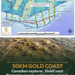
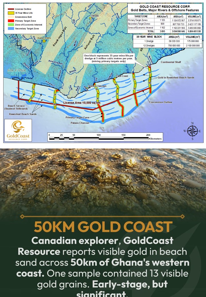
Recent reports indicate that ten offshore gold reconnaissance licenses have been granted covering approximately 10,000 square kilometres of Ghana’s western offshore area, extending for roughly 300 kilometres from Half Assini toward Winneba. It is important to be precise that a reconnaissance license is not a mining lease, and reconnaissance should not automatically be described as commercial gold mining. However, reported exploration plans include geophysical, bathymetric and seismic surveys, coring and sediment sampling. Concerns have also been raised about possible future progression toward prospecting, bulk sampling and shallow-water dredging.
That progression is what Ghana must examine very carefully. Because the environmental question changes dramatically when exploration moves from looking for gold to physically disturbing the seabed to obtain it.
The greatest threat: destroying the habitat that produces the fish
The MPA is designed to protect fish habitat. Seabed mining or dredging, by its nature, involves disturbing or removing seabed material. This creates a fundamental contradiction that Ghana cannot ignore.
If the ecological productivity of the Cape Three Points marine system depends on healthy seabed, nursery and feeding habitats, what happens when those habitats are physically disturbed?
Potential impacts include:
1. Destruction of seabed habitat
The seabed is not simply sand or mud. It supports communities of organisms that form part of the marine food web. Removing or heavily disturbing seabed material can destroy these organisms and change the physical character of the habitat. The result may be a seabed that no longer performs the same ecological functions.
2. Sediment plumes and increased turbidity
Dredging and other intensive seabed disturbance can put large quantities of sediment into the water column. In shallow coastal waters, this can be particularly important. Increased suspended sediment can reduce water clarity, interfere with feeding, affect organisms living on the seabed and deposit material on surrounding habitats. The ecological footprint can therefore extend beyond the exact point where equipment is operating.
3. Damage to nursery grounds
This is perhaps the greatest concern for Ghana’s artisanal fisheries. Young fish require suitable nursery habitats. If those habitats are disturbed, buried, contaminated or otherwise degraded, fewer juvenile fish may successfully survive to adulthood.
That can eventually translate into: less recruitment → fewer adult fish → lower catches → lower incomes.
The scientific work undertaken in the Greater Cape Three Points area specifically identified nursery ecosystems as critical to continued fish production.
4. Disruption of spawning and feeding areas
Cape Three Points is recognised as an important spawning, resting and feeding area for round sardinella and other marine species. Any activity that significantly alters these ecological conditions therefore deserves careful scrutiny. The question is not merely:
“Will the dredger kill fish?”
The more important question is: “Will the activity reduce the ecosystem’s ability to produce fish?”
That is a much bigger question.
What happens to the artisanal fisher?
Imagine a fisherman in Axim, Half Assini, Akwidaa, Cape Three Points, Dixcove or another coastal community. He does not own the fish. He does not own the seabed. His livelihood depends on an ecosystem that he did not create.
If seabed disturbance reduces fish abundance, he may have to travel farther. That means: more fuel → longer fishing trips → higher costs → greater risk → lower profit. For women who process and trade fish, declining landings mean less fish to process and sell. For families, it can mean lower income and greater food insecurity. The impact therefore travels from the seabed into the household. This is why the MPA’s management framework appropriately recognises coastal communities and sustainable livelihoods as integral to conservation.
What should Government do?
HELP Foundation Africa believes Ghana should take the following steps before allowing offshore gold activities to progress into intrusive seabed operations:
1. Publish the exact license coordinates: Ghanaians have a right to know where these licenses are located.
2. Publish the approved work programmes: The public must know exactly what activities are authorised.
3. Conduct a spatial overlay: Government should publish one transparent map showing:
gold licenses + 12-nautical-mile IEZ + Greater Cape Three Points MPA + fishing grounds + spawning areas + nursery areas + sensitive habitats.
4. Conduct an independent cumulative-impact assessment: The assessment should consider fisheries, biodiversity, sediments, water quality, coastal livelihoods and the MPA, not merely the immediate footprint of exploration.
5. Establish a clear “no-go” principle for sensitive habitats: Critical spawning, nursery and biodiversity areas should not be sacrificed for mineral extraction.
6. Do not allow automatic progression from reconnaissance to mining: Every transition to a higher-impact phase should require independent environmental and fisheries evidence.
7. Put fishing communities at the centre of the decision: Fishers, processors, traders, traditional authorities and coastal communities must have meaningful participation not merely be informed after decisions have already been made.
HELP Foundation Africa calls for transparency, independent scientific assessment, meaningful community participation and the application of the precautionary principle before any offshore gold programme progresses to activities capable of substantial seabed disturbance.
Our ocean is not an empty frontier. It is Ghana’s natural capital. Let us protect it.
HELP Foundation Africa Policy Desk. Tel: +233244817020. WhatsApp: +233598069009. Email: info@helpfoundationafrica.org
For media inquiries Contact: Kwadwo Kyei Yamoah (+233 244 817020, Kkyeiyams@gmail.com)